| LM | People in space |
How can we depict a complex interaction between people and nature?
First of all, we need a theoretical framework – a concept that takes into account the diverse possibilities of nature and people in all of their forms and translates them comprehensibly into qualitative and quantitative data and process descriptions.
Nature’s Contributions to People
Nature’s Contributions to People (NCP) evolved out of the economic and scientific conceptualization of the Millennium Ecosystem Assessment of such interrelationships, which focuses on economically assessable ecosystem services. The NCP approach makes it possible to abstract the positive and negative contributions of nature, the diversity of organisms, ecosystems and the associated ecological and evolutionary processes to human’s quality of life depending on the cultural, socio-economic, temporal or spatial context.
This framework by the Intergovernmental Science-Policy Platform on Biodiversity and Ecosystem Services (IPBES) strives to “assess and promote knowledge of Earth’s biodiversity and ecosystems and their contribution to human societies in order to inform policy formulation.” For more insight, please read the full paper.
Why do we need spatial knowledge of processes?
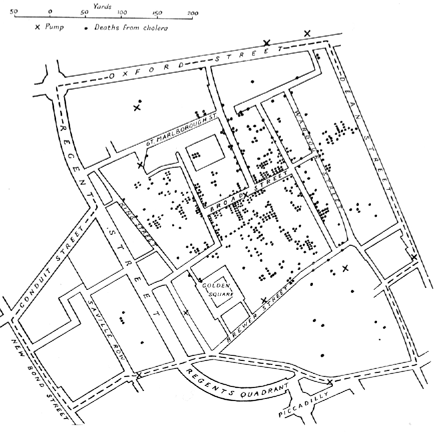
Considering the above context, because space matters for all kinds of interactions between nature and people. Let’s illustrate this point by considering a famous historical example.
In 1854, the London district Soho experienced a cholera outbreak. While the prevailing theory of disease at the time suggested that airborne particles (“miasma”) were the source of the outbreak, Dr. John Snow had another idea. After interviewing residents, he theorized that the public water pump on Broad Street was responsible for the outbreak. Dr. Snow mapped the cases, visualizing the connection between space (distribution of cholera deaths and pumps in Soho, London) and spatial processes (water retrieval). He showed that the closer a house was located to the Broad Street water pump, the greater number of cholera-related deaths occurred there.
 Image: Dr. John Snow’s map of the 1854 cholera outbreak in Soho, London via Wikimedia Commons
What is the role of Artificial intelligence?
Linking nature and people, we are still in the same realm that started with Dr. Snow’s analysis of the cholera outbreak. Yet, it is much more complex. Regardless of whether we are interested in air temperature, degree of vegetation coverage, or solar irradiance at a given location, geodata always have a spatial component. But just because two points on Earth are close together, they are not necessarily similar in every respect. After all, different topographies can mean that moving just a few meters in one direction has a very drastic result in your altitude – valleys, cliffs or mountain peaks are just a few clear examples of this idea.
And what’s more, all of these aspects are influenced by the people who act, who continuously exert influence as actors, who implement the processes in different cultural and economic ways. In order to be able to recognize valid patterns and structures in this complexity and to arrive at relevant statements and insights, parametric or deterministic models are insufficient. Instead, we need intelligent self-learning methods of data analysis and data retrieval.
Video
Unit 1 slides
Additional resources
Peter Lindbrook’s cholera package offers an R-based reanalysis of the Soho cholera outbreak and brings to bear a number of technical, scientific and GI-related concepts that will be applicable throughout the course.
